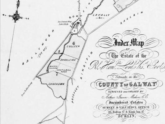
1854 Map of Modern Day Cloonahaha Townland, depicting sub-townlands. 1854 Landed Estate Court Records
Townlands
A townland is a small geographical division of land used in Ireland. It is a unique feature of the Irish landscape and is one of the most ancient divisions in the country. The origins of the townland remains obscure but they are undoubtedly of great antiquity. They existed long before the parishes and counties. Townlands originally consisted of a number of sub-divisions such as gneeves and ploughlands but they are now recognised as the smallest administrative division in the country.
They were used as the smallest geographical unit in both the Tithe Survey and Griffith’s Primary Land Valuation, as well as census returns, and are still in use today. Anything from 5 to 30 townlands may be grouped together to form a civil parish. If you are searching for your family anywhere in Ireland, knowing the Townland they came from is one of the best ways of tracing them. Knowing the Barony, Parish, etc will also be of great help to you, since many townlands share the same name - for example there are 47 Townlands named Dromore and 56 Kilmores. To find which Civil Parish, Barony, Province etc a Townland is in, visit www.thecore.com/seanruad/ or www.townlands.ie.
They were used as the smallest geographical unit in both the Tithe Survey and Griffith’s Primary Land Valuation, as well as census returns, and are still in use today. Anything from 5 to 30 townlands may be grouped together to form a civil parish. If you are searching for your family anywhere in Ireland, knowing the Townland they came from is one of the best ways of tracing them. Knowing the Barony, Parish, etc will also be of great help to you, since many townlands share the same name - for example there are 47 Townlands named Dromore and 56 Kilmores. To find which Civil Parish, Barony, Province etc a Townland is in, visit www.thecore.com/seanruad/ or www.townlands.ie.
Townland Sub-Division
It is important to be aware of townland subdivisions when conducting research. Sub-townlands seldom appear on maps but are used in church records. Very often the placename that was held most dear by an emigrant was the subdivision, and you will likely not find it in a reference book. While researching Beagh, I did not come across any comprehensive list of such sub-townlands, so decided I should try and compile a list of those I could find, and their corresponding modern names. Although from Beagh myself, I have never heard some of these names before, so I encourage anybody with more sub townland names to contact me so I can update this list.
Sources
I studied the Encumbered Estate Court Rental Catalogues relevant to Beagh Civil Parish. The Encumbered Estates' Court was established by an act of the British Parliament in 1849, to facilitate the sale of Irish estates whose owners, because of the Great Famine, were unable to meet their obligations. Essentially they were sale catalogues for prospective buyers, and as such, have great detail and maps included. The following landlords for Beagh were examined; John Prendergast, Lord Viscount Gort (dated 16 May 1854); Daniel McNevin Minor (dated 3 June 1851); Daniel McNevin Minor (dated 13 December 1853); Michael Butler of Walterstown, Clare (17 December 1850); Francis and Walter Butler of Cregg, Galway (31 December 1849). I also have referenced O’Donovan’s Field Name Books of 1837, and map collections available on the Ordnance Survey of Ireland website.
Further examination of the Roman Catholic Baptism register for Beagh Roman Catholic Parish, coupled with corresponding civil birth records for the baptisms with unrecognisable sub townland names, also lead to the discovery of further sub townland names.
Where possible, I have included some information about these sub-townlands from the Estate Court Rental Books, including acreage, and any prominent feature within these townlands. I have included some maps of these sub townlands from the Estate Court Catalogues to give more geographical context.
List of Known Sub Townlands of Beagh
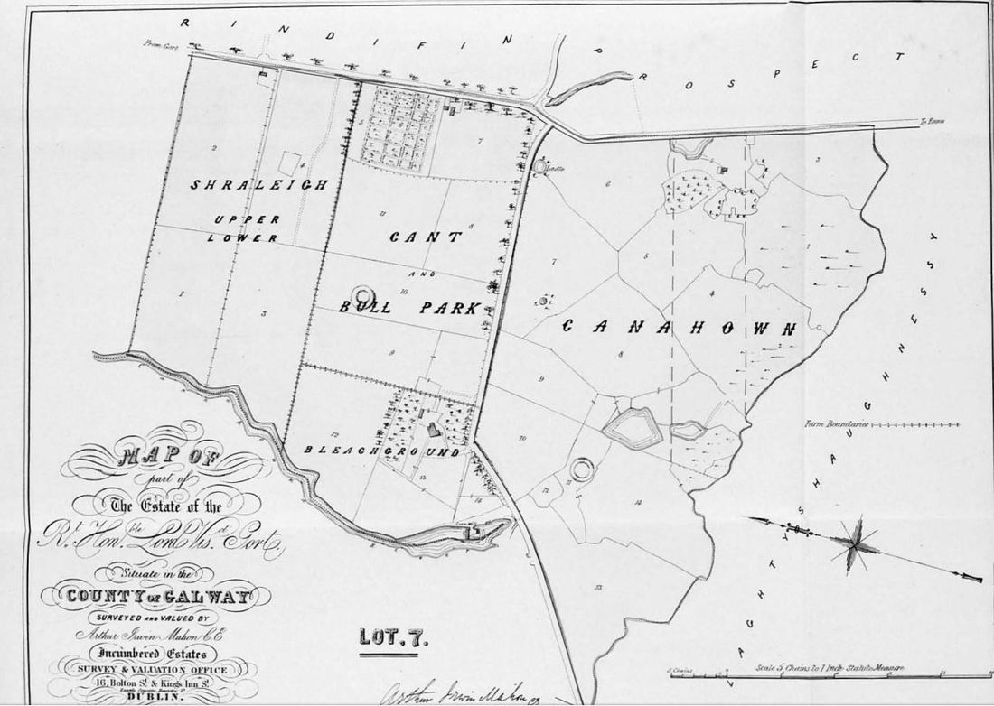
- Cloonahaha townland is made up of the following sub-townlands;
- Culleen (or Cooleen) sub townland. Bellmount Cottage was contained within this sub townland, likely close to the present day site of the Lady Gregory Hotel on the Ennis Road, Gort. Bellmount was the residence of Mr. John Bell, County Cess Collector and Barony High Constable.
- Shraleigh (Upper and Lower)
- Cant Park and Bull Park, which contains a ringfort
- Bleach Ground, which contained Riverview House and the corn mill
- Canahown, contains the ‘ladle’, and also another ringfort opposite Riverview House.
- Cregmahon is also known as Creg. Cregmahon has 228 acres 0 roods 11 perches.
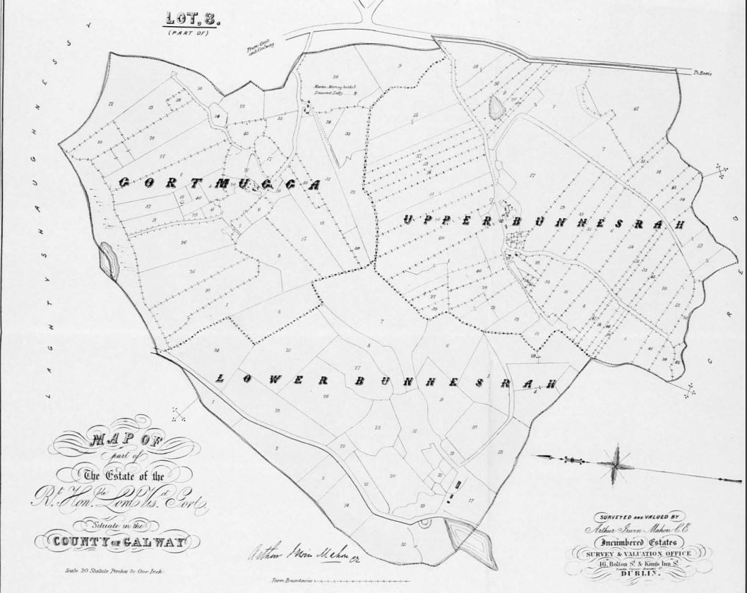
- Bunnesrah (or Bunasragh) is split into the following sub-townlands;
- Gortmugga. This sub townland contained over 6 acres of a bog and common land to tenants of Gortmugga. for a total 121 acres 5 roods 80 perches (worth £46 38 shillings 16 pence in 1853).
- Lower Bunnesrah. There is 2 roods and 20 perches of water in this sub-townland. Total 100 acres 6 roods 68 perches. Land rented at £46
- Upper Bunnesrah. There is over 10 acres of bog recorded in this townland, which is held in common by the tenants of both Upper and Lower Bunnasrah. Total of 147 acres 4 roods 68 perches, rent of £51
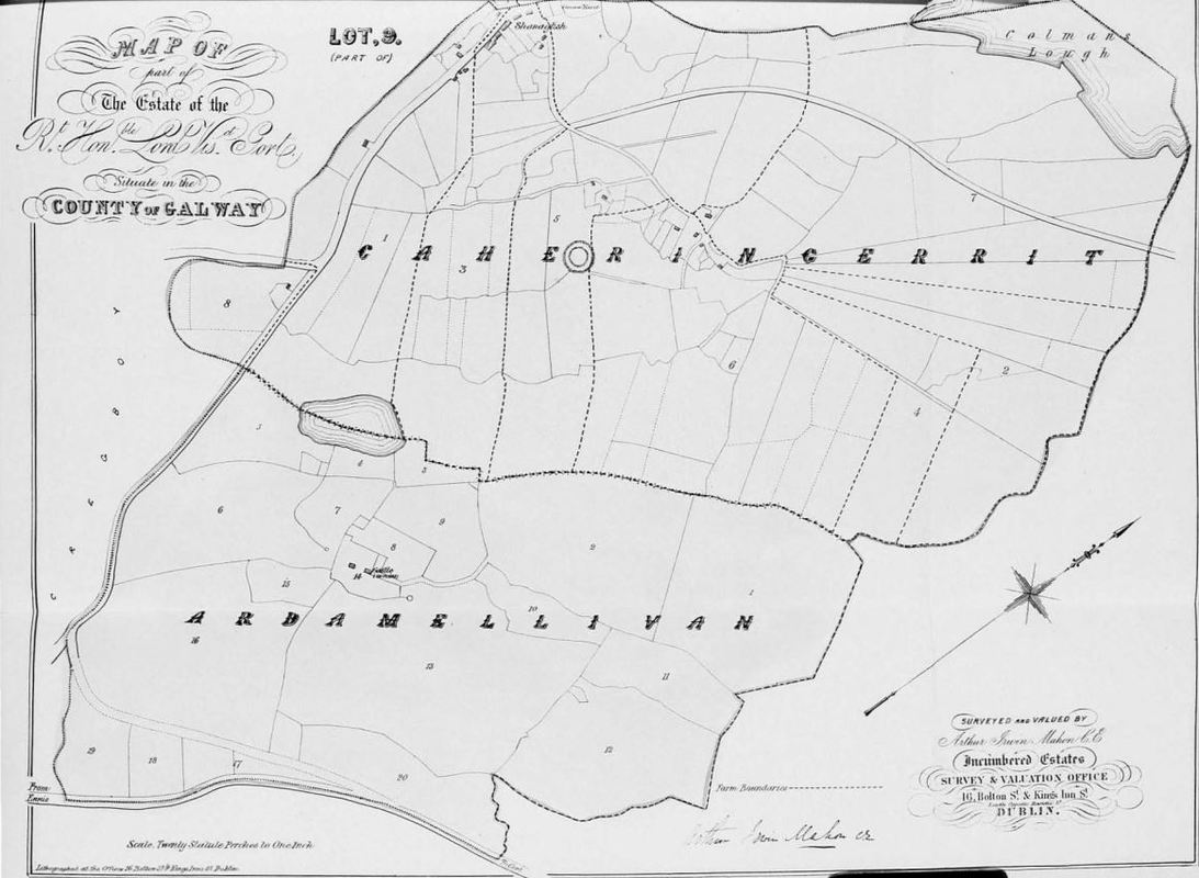
- Ardamullivan was split into four sub-townlands for a total of 496 acres, 2 roods, 2 perches;
- Caheringerrit (or Caheringarrit). This townland contains a ringfort, and is located in present day in northern Ardamullivan townland. In the northern portion of this townland is Colman Lough, and Ardamullivan Lake is shared between this sub townland and Ardamellivan (sic Ardamullivan). This sub townland contains 233 acres 3 roods 13 perches
- Ardamellivan (sic Ardamullivan): contains Ardamullivan castle. 165 acres 35 perches valued at £68 17 shillings
- Gorteenaclare contains 12 acres 2 roods 32 perches worth £9
- Knockrubbleshina (modern day Foxtailhill) contains 84 acres 3 roods 1 perch worth £49, 64 shillings 21 pence
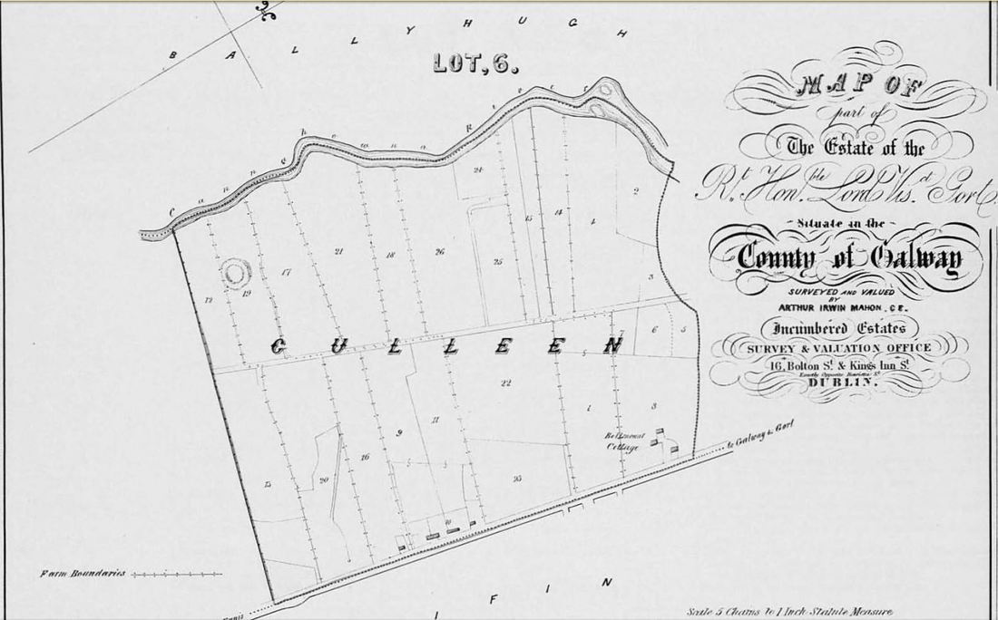
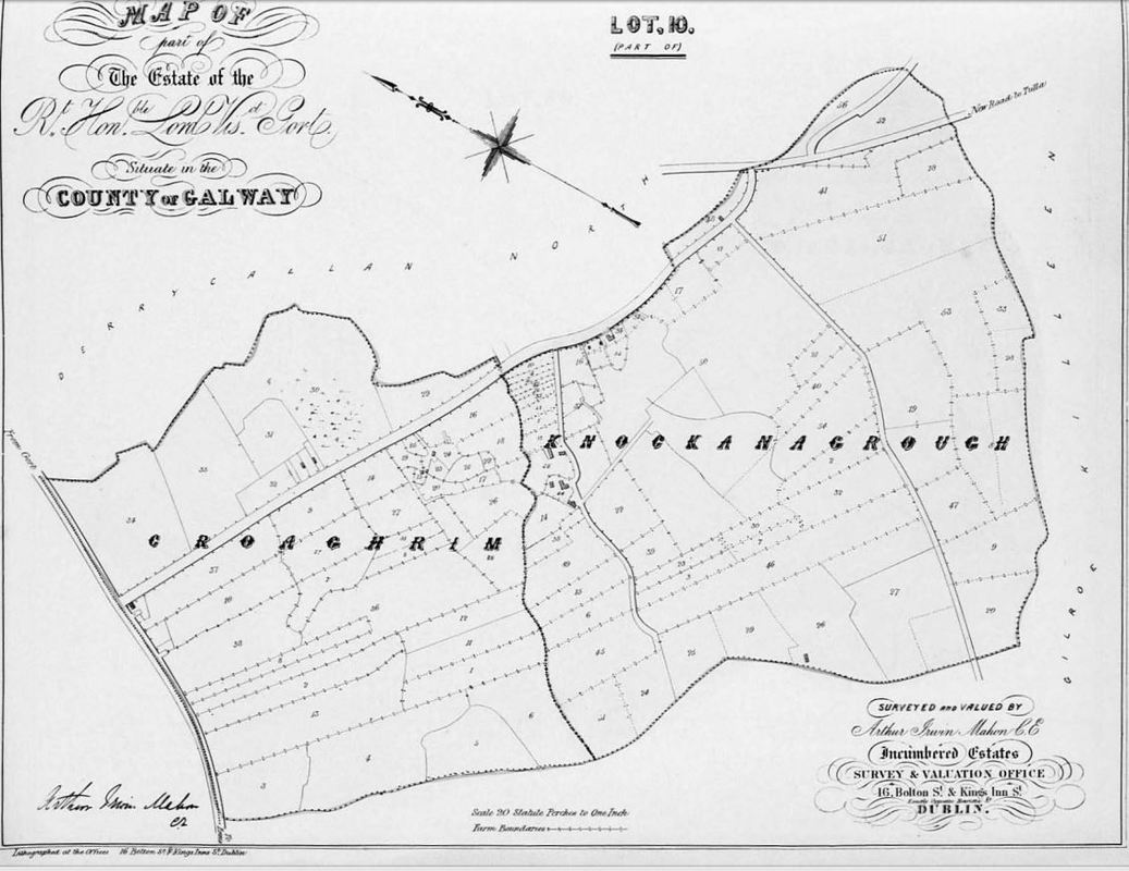
- Laughil was split into the following sub-townlands for a total of 374 acres 1 rood 38 perches;
- Croaghrim: 85 acres 3 roods 17 perches
- Knockmagrough or Knocknagrough (modern day Reekhill): 120 acres 3 roods 15 perches
- Laughil: contains a ringfort, and a small village. Also known as Lahiel. Total 167 acres 3 roods 16 perches
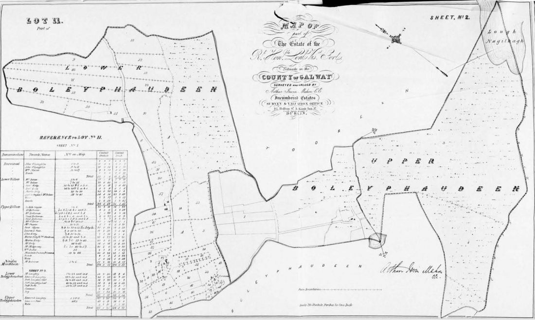
- Boleyphaudeen containing 411 acres 2 roods 3 perches
- Lower Boleyphaudeen: 193 acres 5 roods 16 perches
- Upper Boleyphaudeen: 218 acres 1 rood 22 perches
- Rosvicneil: 32 acres 1 rood 6 perches. It seems likely that this sub townland later became Part of Ballinakill or Boleyphaudeen Townlands.
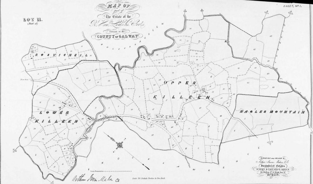
- Killeen containing 447 acres 0 roods 9 perches
- Lower Killeen: 127 acres 0 roods 37 perches
- Upper Killeen and Nagle’s Mountain: 45 acres of common mountain pasturage in Upper Killeen held in common by tenants of Killeen. Total of 374 acres 4 roods 17 perches.
- Derry;
- Rosepark (House Division): 38 acres 0 roods 34 perches worth £48 19 shillings 2 pence
- Parknagrane: 31 acres 4 perches worth £24 14 shillings 7 pence
- Crossford: 47 acres 1 roods 145 perches worth £44 25 shillings 16.5 pence
- Durragh (phonetically ‘Derry’): 81 acres 0 roods 25 perches worth £30
- Rock (also known as Rockdurragh or Rockderry): 58 acres 5 roods 57 perches worth £19 3 shillings 2 pence
- Ballyboy;
- Rosehill: 94 acres 2 roods 29 perches worth £73 14 shillings 8 pence. Ringfort in this sub townland
- Ballyboy: 147 acres 5 roods 90 perches worth £38 35 shillings 7 pence
- Firpark or Furpark: 117 acres 6 roods 210 perches worth £81 29 shillings 19 pence
- Lisheen – based on baptism records
- Ballybane – this comes from the baptism records and civil birth records. It seems possible that this is in fact a transcription error and could refer to ‘Ballyboy’.
- Fiddane;
- Derryowen - it should also be noted that there is a Derryowen townland in County Clare which borders Fiddane on the East. it seems Derryowen refers to portions of Fiddane, as well as the County Clare townland in Kilkeedy Civil Parish.
- Cloonmore
- Castle Lodge. By 1837, Castle Lodge was now part made into a Police Station and occupied by one Constable and 4 Sub Constables.
- Ratorp (or Ratorpe)
- Rathwilladoon
- Newtown Glynn
- Newtown Tubber or Newtown
- Blackwater is a given name for Prospect townland. It is worth mentioning Gort River is named the Blackwater, and it is possible this has some relevance on this sub-townland name.
- Hollymount Townland seems to have also been known as Hollywood
- Lakefield, a known place in Beagh Parish near the entrance to Lough Cutra Castle, is located in the present townland of Prospect. The Historic 25 Inch Map (1888-1913) available on http://map.geohive.ie/mapviewer.html depicts Lakeview House in ruins in this townland by this time period.
- Derrycragg townland seems to have been split between the modern townlands of Knockatoo Mountain or Upper Killeen.
I have also come across Flowervale House (associated with the Mangan family of Gort, who were millers in the town), but have not yet determined which modern townland it is located in.


 RSS Feed
