Introduction
Although the scale of the population changes in and around the Great Famine are well known and have been written about extensively, the magnitude of this enormous demographic event are even more startling when brought to a local level. The Gort Poor Law Union suffered greatly during the Famine, and within the Poor Law Union, some parishes suffered greater than others. This blog post will deal specifically with Beagh Civil Parish, and the townlands within. The objective of this blog post is to give some idea of the distribution of population within Beagh. Beagh is unique in that two extremely detailed and interesting local histories of the parish have been written, but statistical analysis of the impact of the Famine in our parish escapes both of these books, something I hope to address here.
To write any blog post on the declining population of Beagh is a difficult task for two reasons in particular, and these two factors affect any hypothesis drawn from the figures discussed below.
Firstly, as noted in earlier blog posts, Beagh Civil parish is shared across two District Electoral Divisions (D.E.D.), namely that of Ardamullivan, and that of Beagh. A D.E.D. is a former name given to a low-level territorial division in Ireland, which, in 1994, were renamed as Electoral Divisions. Essentially, these administrative districts are used both for means of measuring the population in census records, and population votes during elections. The difficulty here is that some townlands not within Beagh civil parish (e.g. in Gort Civil Parish and Kilbeacanty Civil Parish) are included in these DEDs, and the public information on which this article is based does not allow a breakdown of the figures by townland - the DED is the smallest division you can analyze on the CSO (Central Statistics Office) website. As such, this should be remembered when reading this article, as both DEDs have been combined in order to evaluate population decline in the parish. It should also be remembered that the town of Gort borders the northern half of the parish, which no doubt has a big influence on the figures (particularly in more recent times as the town of Gort has expanded further South and encroaches Beagh).
The second difficulty in this blog post is the lack of accurate data detailing the devastating consequences of the Great Famine in the parish. The Roman Catholic church records begin too late (about 1855) to be of use when examining the Great Famine era in the parish, and civil registration in the country (for Roman Catholics at least) did not begin until 1864, almost 20 years after the Famine. We instead have to rely on statistics compiled from the 1841 and 1851 Census records (the original census records were pulped during a paper shortage in the UK during WWI), but this too has its limitations. With the Famine beginning about 1845, the population loss was undoubtedly higher than the official figures below reflect - we have no way of knowing what the actual population of the parish was when the Great Hunger hit the West coast.
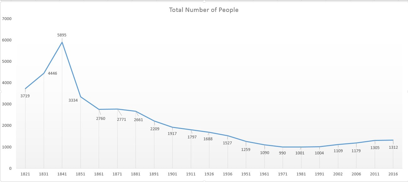
Population Decline Beagh, Eamon Healy
 RSS Feed
